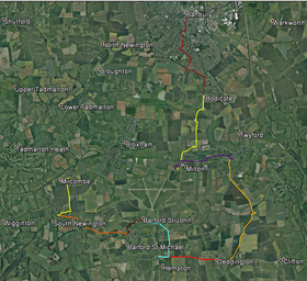
Day 1 - Banbury to Milcombe
|
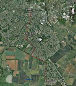
Part 1 - Banbury St Mary's to Bodicote via Easington, St Hugh's
From the west door of St Mary’s go to the main road and turn left along HORSEFAIR to HIGH STREET. Cross this at the zebra crossing with BANBURY CROSS to your right and continue up SOUTH BAR STREET. After St John’s Roman Catholic Church, at St John’s Road cross the main road at the traffic lights and go into BLOXHAM ROAD. Go across BEARGARDEN ROAD and cross BLOXHAM ROAD at the pelican lights just before the top of the slope. Go right and then left into HARRIERS VIEW and continue into EASINGTON PARK. Cross the park by the track, reaching the road (EASINGTON ROAD) on leaving the park. Cross the road in ST GEORGE’S CRESCENT. At the end of ST. GEORGE’S CRESCENT turn right (along HORTON VIEW) and on reaching SPRINGFIELD AVENUE turn right, cross at the zebra crossing, turn left and the right down RUSKIN AVENUE to reach St, Hugh’s church on the right. On leaving St Hugh’s turn left and cross RUSKIN AVENUE before the barriers. Continue down SPRINGFIELD AVENUE to its junction with GRANGE ROAD. Cross Grange Road and turn right, then left into TIMMS ROAD. Before the next road turning cross TIMMS ROAD at the ELMSCOTE ROAD bus stop and go down the bridleway (Bridleway sign). Continue between back gardens to reach Salt Way just after going between two wooden rails at the sides of the path. Turn left and continue along Salt Way with houses on the left and fields on the right. Ignore a rightwards footpath and continue to the road (WHITE POST ROAD). A national Cycle Network sign points right to BODICOTE (1/2) and OXFORD (27). Go along the pavement towards Bodicote, passing the school and Cherwell District Council offices to your left and the recreation ground and Village Hall to your right. WHITE POST ROAD becomes HIGH STREET and then at EAST STREET (to your left) CHURCH STREET begins. Bodicote Church is on the right a short way down CHURCH STREET. |
|
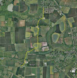
Part 2 - Bodicote to Milton
Turn left out of the South porch of Bodicote Church to reach the road (CHURCH STREET). Turn right along CHURCH STREET. Continue on southwards to the end of the village. After Freemans Road on your left go down the No Through Road, ignoring bridleway and footpath signs on the right hand side indicating other options. Continue downhill and go round a right-hand bend (Restricted Byway sign: Bloxham 2; Cycle track 5 sign) to reach the entrance to Bodicote Mill. In front of the entrance go left over a stream (Sor Brook) and past a gate into the grounds of Bloxham Grove Farm. Follow the drive uphill (ignoring a footpath to the right) and go through a gate and between buildings on your left and a barn on your right. Having past these turn left along the track and at the end of the buildings on your left turn right and go downhill on a track between lines of trees. Go into the next fiield and continue with the hedge on your right. At the far corner of this field go on through the opening into the next field and straight ahead across the field for about 250 metres. Then turn 90 degrees right to face a tree at a field corner about 200 metres ahead. Go to the tree, cross the stile (Footpath marker with a slightly misleading arrow) and go diagonally leftwards down the field to pick up a hedge on your right and follow it on down to reach the field corner. Cross the stile and bridge and turn right across a further bridge and stile. Go ¼ left across the field to the far left-hand corner. Cross the bridge and follow the right hand field boundary. Go through the gate, under the old railway bridge and up the road in Milton vallage. Ignore the forst road on the right and continue up, taking the right-hand road fork to pass in front of The Black Boy inn and reach Milton Church on the right. |
|
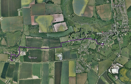
Part 3 - Milton to Adderbury
Returning from the Church to the road turn left, pass the Black Boy Inn and, ignoring the right-hand turn onto towards the main road, continue down into the village. At the fork keep rightwards and go on back down to the old railway bridge. Go under the bridge and turn right along the track with the railway embankment. When the track swerves right between trees to cross the line of the railway continue straight on with the line of the railway to your right into the next field and on to its far corner of the field. Turn left at the field corner and follow the hedge on your right to a stile (footpath marker). Cross this and continue with the field boundary to your left to a stile at the far corner of the field. Go over or through this stile and continue between buildings, ignoring a footpath sign (Bloxham Grove) to your left. The road you come to is MANOR ROAD. At the fork stay left to reach the main road (CROSS HILL ROAD) with ADDERBURY PARK opposite. Continue straight on along CROSS HILL ROAD, passing ROUND CLOSE ROAD and DOG CLOSE on your right and coming into NEW ROAD and then WATER LANE. After the first of the bridges cross the road and go down a footpath (footpath sign). Follow this with a stream on your left to a bridge (footpath sign) which takes you over the stream and into the churchyard. Go up towards the church and turn right to pass beneath the tower and then left to reach to the south porch. |
|
Part 4 - Adderbury to Deddington
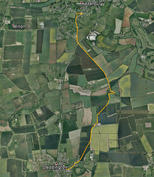
Leave the Church and turn immediately right and right again to pass beneath the tower. Turn left and go down through the churchyard to a stone bridge. Cross this and turn immediately left (footpath sign TO MILL LANE) along the stream to your left. Just before the old mill built across the stream turn right and cross a bridge. Turn left immediately on crossing and follow path along the stream to your left, passing brickwork of the old railway embankment on your right. At a left-hannd bend of the stream turn left to a stile. Cross the stile and follow the path along a fence to your right to a gate at the far side of the field. Go through the gate and up across a concrete roadway which runs between two large metal gates (you are at Adderbury Pumping Station). Continue uphill between trees to emerge onto BERRY HILL ROAD. Turn left to reach the main road (A4260) and cross it. Go down the bridleway immediately opposite BERRY HILL ROAD (bridleway sign CLIFTON 2 ¼ ). The path runs between trees initially and then with a hedge on the left and downhill. Where the path meets a tarmac roadway do not turn right towards the farm buildings but continue to the cottages on the far side of a stream. Immediately after the cottages on the right and just before the building on the left turn right (no sign at this point) and go between trees to a field at a bridleway / footpath sign (DEDDINGTON CIRCULAR WALK) just before a stream. Cross the field, going straight ahead (at an angle of 90 degrees to the field edge) towards a tree at the side of a stream. Then follow the stream round a right/left bend towards a small barn at the field edge. Continuing on the line of the stream where this disappears, pass the barn to your right to reach a gate. Go through the gate (footpath marker) and then diagonally right up the filed to its top right hand corner. At the corner, ignoring a gap in the hedge on your left before the corner) go through the gap and briefly under trees to a stile to which the path, going slightly leftwards, leads. Cross the stile, continue at the top of the field with the hedge on your left for about 150 metres and then turn half right towards a stile (in a fence) just in front of the right hand end of farm buildings. Go ¾ right up to a stile in the next fence just to the left of a gate (footpath marker). Continue to the tarmac roadway and turn right (footpath marker DEDDINGTON CIRCULAR WALK). Continue on th roadway round a left hand bend and go path a hedge-end on your left. At a gap in the hedge on your right go ¼ right across the field ahead of you, cross a ditch and go through the hedge (footpath sign). Cross the field towards the far right corner at an angle of 30 degrees right, passing to the right of a clump of trees in the field. A few metres after passing the fence on your right leave the field through a gate and cross EARLS LANE. Do not turn right down EARLS LANE but continue into Deddington along the pavement of the main road. Pass HOPCRAFT LANE on your left and turn right up CHURCH STREET, continuing round the left hand bend to reach Deddington Parish Church |
|
Part 5 - Deddington to Hempton
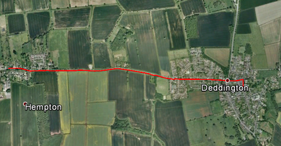
From the church porch go straight ahead through the gate to the road (CHURCH STREET) and turn right and then right again at the first opportunity to pass the church tower. Continue on to the houses ahead of you, passing the gates to a large house on your right adjoining the churchyard, and turn left. Go on to the traffic lights at the crossroads. Turn right to reach the pelican crossing, cross the main road (A 4260) and turn left and then right into the HEMPTON ROAD (B 4031). Go on to another pelican crossing near the end of the village. Cross the road here and continue on towards Hempton, crossing the entrance to the WINDMILL CENTRE to reach the pedestrian/cycle track to the left of the road. At the bus stop at the end of the track, with ST JOHN’S WAY opposite, cross the main road and continue along it past a point at which the road narrows to reach Hempton Church on the right. |
|
Part 6 - Hempton to Barford St John
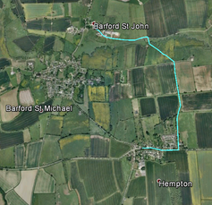
Turn left out of the church and retrace your steps to ST JOHN’S WAY. Cross ST JOHN’S WAY, continue along the verge and take the first left turn down a metalled track (this is Snakehill Lane). Follow the track downhill past a footpath (footpath sign) crossing the track. At the junction with a track (SUMMER LEY) leading to Blackingrove Farm to the right, cross the track and go through a gate into the field (footpath marker). Go ½ left across the field to a gate. Go through the gate and continue on the same line to further gates (footpath marker). Go through the gates, crossing the stream and continue to the gate ahead across the field. Go through this, past the old mill building to your left and onto the track. Turn left and continue along the track, past a cattle grid (footpath marker) and then past barns on the right. Go into the farmyard, through it and on between the cottages of Barford St John. After the cottages a sign on the left of the road indicates ST JOHN’S CHURCH which is reached via an entry on the right to a large house and the churchyard gates. |
|
Part 7 - Barford St John to Barford St Michael
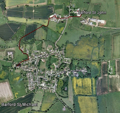
Return from the church to the road, turn right and go to the main road. Turn left and cross into MEAD ROAD. In front of Mead Farm take the right fork, passing the farmyard on your right. Continue past the end of a breeze block and corrugated iron barn on your left and turn left at the end of the fence (footpath signs – not indicating the right direction. Follow the field edge round a right hand bend to a footbridge. Cross the footbridge (footbridge sign) and go diagonally right across the field, passing a stanchion in the field to your left. Enter the trees and follow the path initially leftwards to a footbridge over the river. Cross this and follow the path to a lane which winds up to the main road. Turn right at the main road and cross to the steps into the churchyard to reach Barford St Michael Church. |
|
Part 8 - Barford St Michael to South Newington
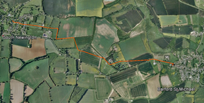
From St Michael's return down the path and turn left out of the churchyard. Take the footpath on the right as you near the top of a rise on a slight leftwards bend in the road. Go 1/3 left across the field to a stile, after which continue slightly right of straight ahead to a stile at the corner of fence and garden. Over the stile turn right up the track and cross another stile straight ahead. Go down to and through a group of trees (footpath marker) and straight across the next field. Go through the hedge (gate, footbridge, gate) and slightly right to another gate. Go through this and up the field to the gate top-left. Through this, turn left along the hedge. At the field corner turn right along the hedge and descend the field with the hedge on your left until you reach a gate in the hedge. Go through this and across the field. Cross a footbridge and go through a gate and across the next field, than through another gate and across another field. At the field's end go through the gate and straight on along a track. Where the track bends right go straight on down a narrow lane and continue past GREEN LANE on your left, along THE TOWN to the Church of St Peter ad Vincula on your right. |
|
Part 9 - South Newington to Milcombe
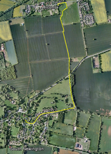
Leave the churchyard by the gate through which you entered and turn left. Continue to MOOR LANE and turn left down it to reach the restricted byway THE BAULK (signed at the end of the houses). Go down THE BAULK, cross the river (the Swere) via a footbridge and follow the track round a left-hand bend uphill to the main road (A 361). Take the left fork to the main road, and cross it onto a footpath (footpath sign MILCOMBE ½ on the far side of the road). Follow the path along the right-hand field boundary (ignore the gap to the right) to the top right-hand field corner then go into the next field diagonally adjoining. Follow the left-hand field boundary in the direction of Milcombe Church ahead of you to a gate at the field corner (there is as short right/left bend en route). Go through the gate, continue along the left-hand boundary and then curve right and along the fence to your left. Turn left at the first opportunity and go on between fences to the road. Turn left to reach Milcombe Church. |
| Section | From | To | Distance | Day Total |
|---|---|---|---|---|
| 1 | Banbury St Mary's | Bodicote | 2.53 | 2.53 |
| 2 | Bodicote | Milton | 2.11 | 4.64 |
| 3 | Milton | Adderbury | 1.73 | 6.37 |
| 4 | Adderbury | Deddington | 3.17 | 9.54 |
| 5 | Deddington | Hempton | 1.54 | 11.08 |
| 6 | Hempton | Barford St John | 1.54 | 12.62 |
| 7 | Barford St John | Barford St Michael | 0.78 | 13.40 |
| 8 | Barford St Michael | South Newington | 1.88 | 15.28 |
| 9 | South Newington | Milcombe | 1.19 | 16.47 |
