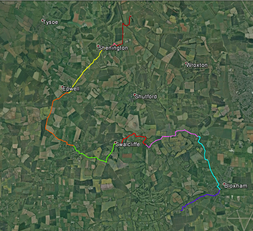
Day 2 - Milcombe to Alkerton
Part 10 - Milcombe to Bloxham
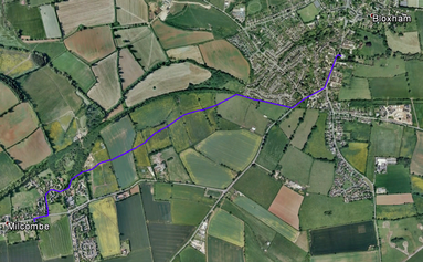
Go out onto the road and turn right. Cross the road and turn left down CHURCH LANE. Pass Barlow CLOSE on the left and continue on church Lane as it turns right (ignore PARADISE LANE to the left). Continue past FERNHILL CLOSE on the left. As the road bends right go through a gate between two house drives (footpath sign BLOXHAM 1). Follow the path between walls and then with a wall on the right. At the end of the wall at agate emerge onto the track and continue straight on. As the track turns left, go through a gate marked FOOTPATH. Continue towards Bloxham Church spire in the distance. Go through a gate and across a field to a further gate. Go through this into the next field, turning left and then right as you enter so as to keep the electric fence on your right. Continue to another gate and on straight across the field to a further gate. Go through this, across the track and through the next gate. Go straight across the field towards the church spire. Go through a gate, across the path, over a stile and cross the field aiming slightly left of the church spire. Go through the hedge and follow the path a little leftwards across the field. Go through a gate and slightly left to a further gate. Cross the field to the next gate. Cross the next field and go over the brook via gates and a footbridge. Go 2/3 left and follow the path as it curves right, passing the entrance to the nature reserve, to reach the back of houses. Continue through a gate into the recreation ground along the back of the houses to the top left-hand corner of the recreation ground. Leave this via the steps and turn left on the main road. Go to and cross the road-junction (signed TADMARTON 3), with a petrol station opposite on the main road, continue past a mini-roundabout and cross the road to reach Bloxham Church.
Go out onto the road and turn right. Cross the road and turn left down CHURCH LANE. Pass Barlow CLOSE on the left and continue on church Lane as it turns right (ignore PARADISE LANE to the left). Continue past FERNHILL CLOSE on the left. As the road bends right go through a gate between two house drives (footpath sign BLOXHAM 1). Follow the path between walls and then with a wall on the right. At the end of the wall at agate emerge onto the track and continue straight on. As the track turns left, go through a gate marked FOOTPATH. Continue towards Bloxham Church spire in the distance. Go through a gate and across a field to a further gate. Go through this into the next field, turning left and then right as you enter so as to keep the electric fence on your right. Continue to another gate and on straight across the field to a further gate. Go through this, across the track and through the next gate. Go straight across the field towards the church spire. Go through a gate, across the path, over a stile and cross the field aiming slightly left of the church spire. Go through the hedge and follow the path a little leftwards across the field. Go through a gate and slightly left to a further gate. Cross the field to the next gate. Cross the next field and go over the brook via gates and a footbridge. Go 2/3 left and follow the path as it curves right, passing the entrance to the nature reserve, to reach the back of houses. Continue through a gate into the recreation ground along the back of the houses to the top left-hand corner of the recreation ground. Leave this via the steps and turn left on the main road. Go to and cross the road-junction (signed TADMARTON 3), with a petrol station opposite on the main road, continue past a mini-roundabout and cross the road to reach Bloxham Church.
|
Part 11 - Bloxham to Broughton
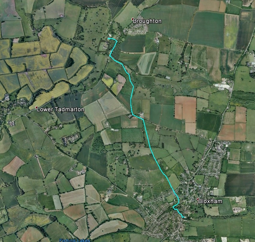
Turn right out of the South Porch and go to the road. Cross the road into HAWKE LANE almost immediately opposite. Turn right down Hawke Lane (there is a sign directing to the BAPTIST CHURCH) and continue past the Baptist Church on your right to reach LITTLE GREEN /UNICORN Street. Cross and go down an alley (FROG LANE), the entrance to which is slightly to your left. Continue down and to the left, then turn right, cross a stream and turn right again to emerge into LITTLE BRIDGE ROAD. Turn left and follow LITTLE BRIDGE ROAD, keeping left at the fork, to COURTINGTON LANE. Cross into the lane opposite and continue through a gate into the field. Follow the right hand boundary of the field up to the gate at the top right-hand corner and then on through further gates. Shortly after the track begins to descend, you reach steps and a gate into a field. Go down the field to its bottom left-hand corner. Go through the gate and turn left along the road, passing Ells Farm to your right and then turn down to a footpath opposite an electrical installation to your left (footpath marker). Follow the field edge with trees on your right to a stile. Cross this and initially follow the hedge on your left as it curves leftwards and then leave the hedge to strike diagonally left across the field on a track that takes you to a stile. Cross this and go ½ right across the field to its right hand corner. Go over stile and continue on the same line across the field to the gap between the river on the right and the pumping station on the left. Go through the gap, turning slightly rightwards, to reach a stile onto the road (footpath sign). Turn right and cross the road (the verge on the far side is more suitable for walking) to reach a lay-by. Continue past the house on the left and continue for about 200 metres. Before reaching a further house on the left, and opposite a lay-by on the right, turn left down a footpath (footpath sign: FOOTPATH TO THE CHURCH). Follow the footpath across the bridge over the stream, through the gate into the churchyard and round to the south door of Broughton Church. |
|
Part 12 - Broughton to Tadmarton
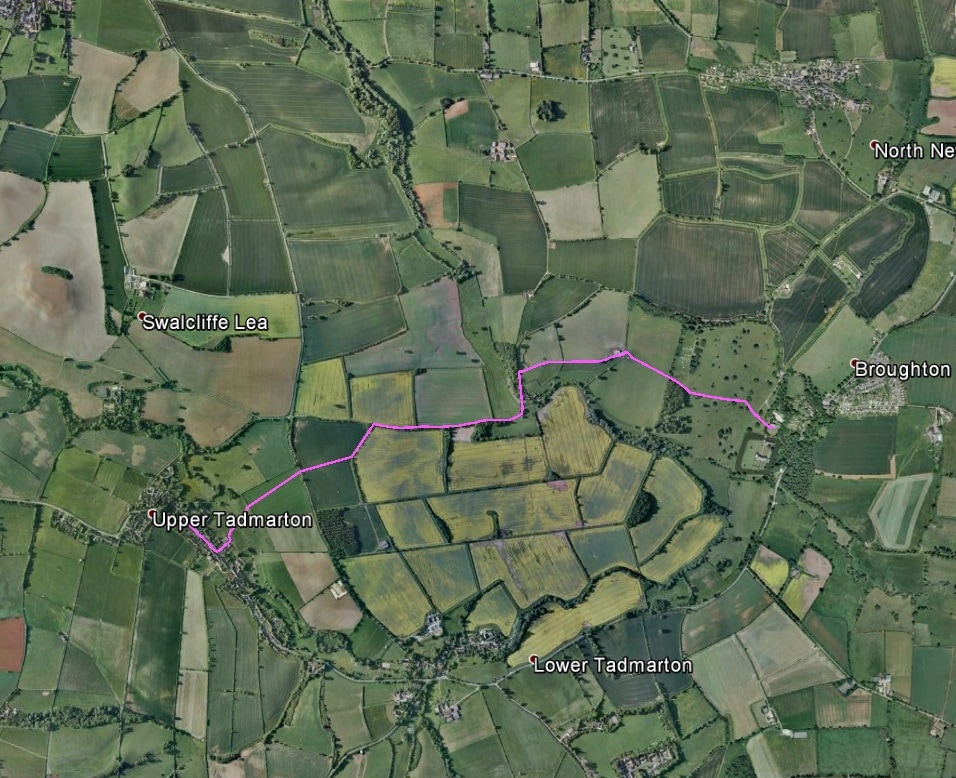
Leave the church and turn right down the path to a gate onto the road. Goo straight ahead on the road and then on grass up the slope aiming to the right of the trees immediately ahead. Then follow a low grass bank as it curves up towards a group of trees. At the top of the pass pass to the right of these trees to reach a gate and continue towards a barn. At the barn cross a stile to the left (footpath marker)and follow the right-hand field boundary to a further stile at the field corner (footpath marker). Cross this and continue to the far right corner of the field keeping close to the right-hand field boundart to reach a gate which leads onto a track (footpath sign BROUGHTON 1). Go left down the track which curves slightly rightwards at the entrance to farm building on the left. Continue on off the metalled track a few metres to a stile (footpath marker, bridleway sigN LOWER TADMARTON ¾). Cross the stile or go through the gate. Ignore the bridleway and follow the track as it curves rightwards up the slope. Go through a gate and continue uphill on the track passing a stone barn and a field entrance to your left anf then the end of a hedge on your right. A few metres before the next hedge ahead to the right turn in left at a field entrance (there is a Permissive Access map at this point). Follow the right-hand field boundary to where it turns at an angle leftwards and go through the hedge, then across the field slightly left of straight to reach a gate in the hedge. Go through this, cross the road to the gate opposite (footpath sign: BROUGHTON 1½ , TADMARTON 1/2 Follow the path downhill to the stream and immediately on crossing this turn right (footpath marker). Continue towards the gap between two houses ahead slightly to your left up the slope. Cross the stile, turn left, then immediately right and follow the lane (BAKERS LANE) round left to reach the main road. Cross the road and turn right into the Churchyard and continue to the south door of the church. |
|
Part 13 - Tadmarton to Swacliffe
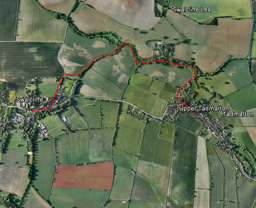
Turn left out of the south door of the church and continue through the churchyard agte and along the path which rises away from the road. Turn right and go down to the road to reach a metal barrier. Cross the road and go into the road signed SWALCLIFFE LEA ¾ and SHUTFORD 2. Shortly after the first set of houses turn left into a field via a gate (footpath sign SHUTFORD 1 ½ . Follow the path ¼ right to the next gate and then 1/3 left across the field down to a stream and across a footbridge (footpath marker). Pass between ponds and go up the slope eventually following a hedge on your left. At the field corner go through the hedge (footpath marker), across the road and through the gate. Cross the field to the road (footpath marker and footpath sign TADMARTON ½ SHUTFORD 1 ¾ . Turn left along the road ignoring the footpath to Shutford. Go round a left-hand bend keeping to the metalled road and ignoring the bridleway going straight on (signed NO VEHICLES BEYOND THIS POINT). Continue on over as stream and up into Swalcliffe. The church tower is visible for much of this stretch. Ignore another bridleway sign at a left-hand bend up into the village. Pass the Village Hall on your right and turn right on the main road to reach the church via steps on your right. |
Part 14 - Swacliffe to Sibford
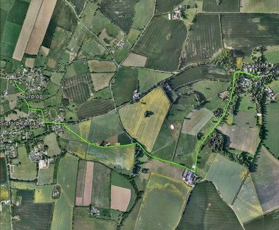
Leave the church and go down the steps to the road. Turn right and continue past Swalcliffe Barn. At The Tithings cross the road to Park Lane and the entrance to Sibford Park School. Follow Park Lane round a left hand bend and then on for about half a mile until you reach a group of farm buildings at a road junction with a barn in front of you across the road. Turn right and go up the road. After about 5 minutes pass driveways to the left and then a house on the left, reaching the entrance to the driveway to the house. Turn into the entrance to Folly Farm on the left at a bridleway/footpath sign, the bridleway indication being SWACLIFFE COMMON ½ , and the footpath indication SIBFORD FERRIS ½. Take the Sibford Ferris direction, following the track round a right hand bend and continuing with the hedge to your right past the entrance to the Folly Farm farmhouse and on past barns and silos on your right until you reach a gap in the hedge where you take a right turn diagonally across and down the field, following the path to the far right hand corner to come out onto the road. Turn left and continue for about 200 metres to the shop and then a little further to a footpath entrance on the right at The Old Malt House. Turn right and follow the track. Come off the track to the left just before two driveways to some houses to the right of the track. Continue down to a stile and turn left, having crossed it, and go along the top of the field. Leave the field by a stile and then go down into the road via another stile, this time a rather precipitous stone-stepped one. Turn right and go down to the bridge over the stream (perhaps crossing and re-crossing the road to keep on the pavements). Continue up a right hand bend, ignoring the first footpath on the left hand side of the road to take the second, just after the BURDROP sign, going through a gate where the footpath sign indicates TO CHURCH. Go rightwards diagonally up the field to a gate in the churchyard wall and continue to the church.
Leave the church and go down the steps to the road. Turn right and continue past Swalcliffe Barn. At The Tithings cross the road to Park Lane and the entrance to Sibford Park School. Follow Park Lane round a left hand bend and then on for about half a mile until you reach a group of farm buildings at a road junction with a barn in front of you across the road. Turn right and go up the road. After about 5 minutes pass driveways to the left and then a house on the left, reaching the entrance to the driveway to the house. Turn into the entrance to Folly Farm on the left at a bridleway/footpath sign, the bridleway indication being SWACLIFFE COMMON ½ , and the footpath indication SIBFORD FERRIS ½. Take the Sibford Ferris direction, following the track round a right hand bend and continuing with the hedge to your right past the entrance to the Folly Farm farmhouse and on past barns and silos on your right until you reach a gap in the hedge where you take a right turn diagonally across and down the field, following the path to the far right hand corner to come out onto the road. Turn left and continue for about 200 metres to the shop and then a little further to a footpath entrance on the right at The Old Malt House. Turn right and follow the track. Come off the track to the left just before two driveways to some houses to the right of the track. Continue down to a stile and turn left, having crossed it, and go along the top of the field. Leave the field by a stile and then go down into the road via another stile, this time a rather precipitous stone-stepped one. Turn right and go down to the bridge over the stream (perhaps crossing and re-crossing the road to keep on the pavements). Continue up a right hand bend, ignoring the first footpath on the left hand side of the road to take the second, just after the BURDROP sign, going through a gate where the footpath sign indicates TO CHURCH. Go rightwards diagonally up the field to a gate in the churchyard wall and continue to the church.
|
Part 15 - Sibford to Epwell
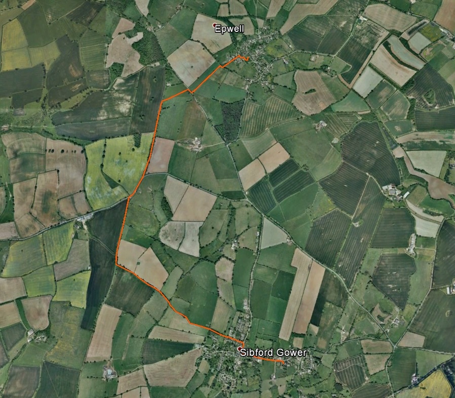
Turn right out of the church and then left along the road, passing the primary school to reach a crossroads (road sign on a wall on the right: MAIN STREET leading to ACRE DITCH). Turn right into POUND LANE and then left down BACKSIDE LANE (bridleway sign). As the metalled track curves right to become a driveway to farm buildings, go straight on to a gate (bridleway marker). Go through this and continue straight on down the hill following a hedge on your right (you may need to negotiate a gate before you reach the hedge). Follow the bridleway as it curves right with the hedge on the right and a grass bank on the left and go down to a gate. Go through this and continue downhill along the hedge to your left. After about 70 metres come away from the hedge to take a slightly rightwards diagonal down to a gate. Go through the gate (bridleway marker), cross the stream and continue up the hill to reach a T-junction with another track just below the brow of the hill (bridleway post). Turn right and follow the track to a gate leading onto the main road. Go straight up to the road, turn right and go round the left-hand bend. At a safe distance from the next bend in the road (rightwards) cross to the left hand verge and leave the road at the right-hand bend to take a bridleway (bridleway sign). Go through or round the gate ahead of you and continue past a mast on the right. About 100 metres after the mast turn right to go through or round a stile into the field. Go ½ left diagonally across the field to the far corner and then out onto the road (footpath sign BEGGARS LANE). Turn right, cross the road and then shortly turn left (footpath sign: EPWELL ½) and through the gate. Follow the hedge on your left downhill. At he bottom of the field turn right and after about 20 metres left through an unmarked gate. Follow the left-hand field boundary to the field corner and continue with houses on your right down into the road (footpath sign). Turn right and follow the road round left to a footpath sign on the right indicating TO CHANDLeRS ARMS and D’ARCY DALTON WAY. Turn right up the track and left through a gate in the churchyard to reach Epwell Church. |
Part 16 - Epwell to Shenington
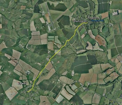
Leave the church and turn left to reach the road. Go to the road sign ahead of you indicating BANBURY. Do not take the Banbury direction but go downhill with the Village Hall to the left and then a sign BIRDS LANE on the right. Cross the stream and keep right ass the road forks. At YARN HILL HOUSE there is a footpath sign indicating SHENINGTON 1 ¾ DARCY DALTON WAY. Go through the gate into YARN HILL COTTAGE and continue on the driveway and then across the lawn at a footpath post to a post with a footpath marker and continue as the path curves left to a stile. Cross the stile and follow the track to a gate in a fence (do not turn left through the hedge) and continue straight across the field to a further gate. After the gate aim slightly to the right of the pylon ahead of you and continue to the far left corner of the field (ignoring an opening in the hedge to your left before you reach the gate.) Follow the left-had boundary hedge in the next field and go through a gate and out onto the road. Turn left and opposite the barns to your left cross the stile on the right-hand side of the road at a footpath sign indicating SHENINGTON 1. Go to the telegraph pole ahead of you and then slightly rightwards down the hill to a stile and footbridge. Cross the stile and the stream and go straight on up the field to a further stile. Across this, go half right across the field towards the far right-hand corner. Just before a gate into the next field turn left at a footpath marker to reach a stile. Cross the stile and turn right, passing a footpath post, towards a gate and a fence with a stile. Crossing the stile continue, initially along the fence to the left, past a spring on the right, over or past a stile and, past a pool on the right, following the path as it curves leftwards to a gate. From the gate go slightly left across the field to the fence opposite and then turn right and up along the fence to a further gate. In the next field continue with the hedge to your right to the far right-hand field corner. Cross the stile and go ¼ left downhill to the leftmost tree of the line of trees ahead of you. Cross the footbridge and still and follow the fence and hedge on your right uphill to a further stile. Cross this to reach the main road. Go right on the road and pass THE LEVEL and MILL LANE on the right to reach the Green at the right (at STOCKING LANE on the left). Turn right to reach the Church by way of the entry in the far right-hand corner of the Green.
Leave the church and turn left to reach the road. Go to the road sign ahead of you indicating BANBURY. Do not take the Banbury direction but go downhill with the Village Hall to the left and then a sign BIRDS LANE on the right. Cross the stream and keep right ass the road forks. At YARN HILL HOUSE there is a footpath sign indicating SHENINGTON 1 ¾ DARCY DALTON WAY. Go through the gate into YARN HILL COTTAGE and continue on the driveway and then across the lawn at a footpath post to a post with a footpath marker and continue as the path curves left to a stile. Cross the stile and follow the track to a gate in a fence (do not turn left through the hedge) and continue straight across the field to a further gate. After the gate aim slightly to the right of the pylon ahead of you and continue to the far left corner of the field (ignoring an opening in the hedge to your left before you reach the gate.) Follow the left-had boundary hedge in the next field and go through a gate and out onto the road. Turn left and opposite the barns to your left cross the stile on the right-hand side of the road at a footpath sign indicating SHENINGTON 1. Go to the telegraph pole ahead of you and then slightly rightwards down the hill to a stile and footbridge. Cross the stile and the stream and go straight on up the field to a further stile. Across this, go half right across the field towards the far right-hand corner. Just before a gate into the next field turn left at a footpath marker to reach a stile. Cross the stile and turn right, passing a footpath post, towards a gate and a fence with a stile. Crossing the stile continue, initially along the fence to the left, past a spring on the right, over or past a stile and, past a pool on the right, following the path as it curves leftwards to a gate. From the gate go slightly left across the field to the fence opposite and then turn right and up along the fence to a further gate. In the next field continue with the hedge to your right to the far right-hand field corner. Cross the stile and go ¼ left downhill to the leftmost tree of the line of trees ahead of you. Cross the footbridge and still and follow the fence and hedge on your right uphill to a further stile. Cross this to reach the main road. Go right on the road and pass THE LEVEL and MILL LANE on the right to reach the Green at the right (at STOCKING LANE on the left). Turn right to reach the Church by way of the entry in the far right-hand corner of the Green.
|
Part 17 - Shenington to Alkerton
Turn left out of the main door of Shenington Church and leave the churchyard by the east gate to enter Chapel Lane. Turn left and cross the main road and turn right. After about 40 metres you reach a sign for the D'Arcy Dalton Way. Turn left down the path. Go through a gate and follow the path downhill to a footbridge over a stream (near a telegraph pole). Cross the footbridge via a stile and continue on to a gate. Go through the gate and then 1/2 left, aiming for the corner of a wooden fence. A little after the fence corner and before the telegraph wires, go right along the fence and then right towards buildings and a gate. Go through the gate and between the buildings to a further gate with a stile. Cross the stile and continue to a gate on the left hand side of the drive before you reach the main road. Go through the gate and climb the steps to the Church of St Michael and All Angels, Alkerton (left at the top of the steps). |
|
Part 18a - Alkerton to Hornton Grounds Farm (B&B)
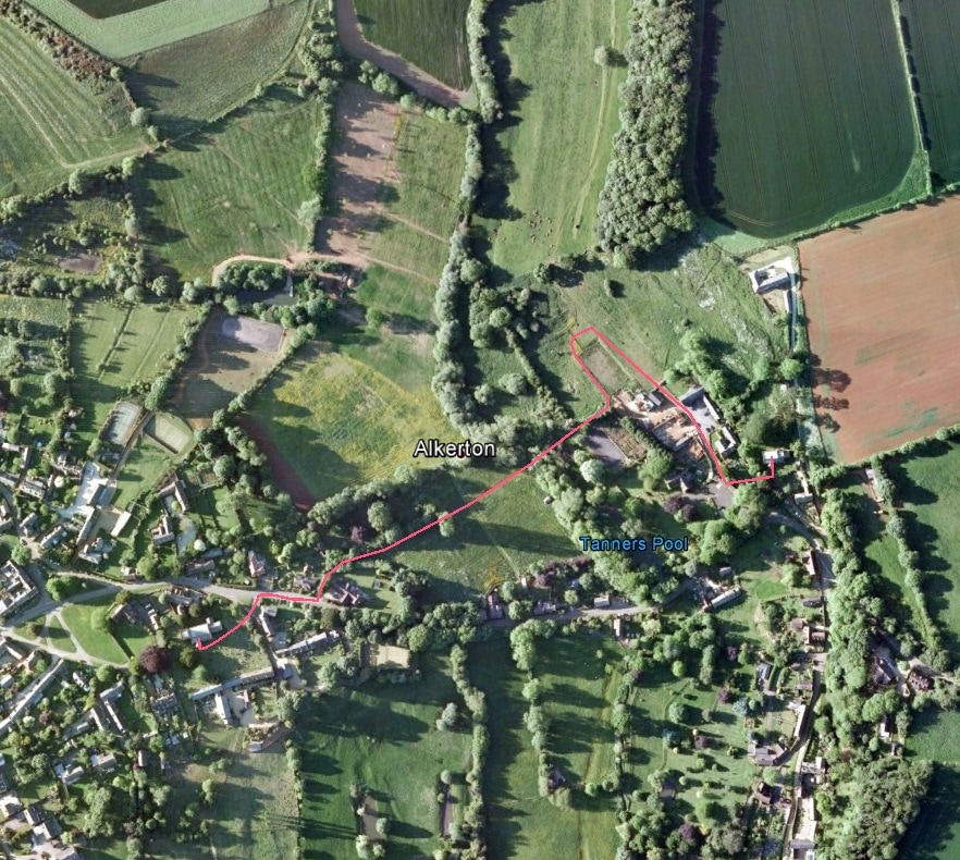
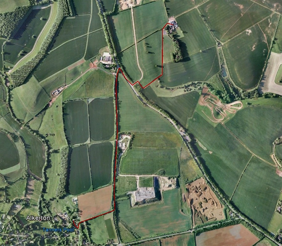
Leave Alkerton churchyard and continue past the steps by which you came up with the Old Rectory on your left. At the end of the drive turn left onto a footpath. Before Hill Barn (Access Only sign) bear right up the slope with the path curving right. Go through a gate into a field and continue along the hedgerow on your left. Go through a further gate in the field corner and continue to a stile. Cross this into the road and turn left. Continue along the road, passing the Recycling Centre, until you reach the A 422. Turn right along the verge and then cross the road to reach the entrance to Hornton Grounds Farm. Having turned left off the A422, after about 50 metres turn right at the signs for Hornton Grounds and Hornton Grounds Farm and follow the track round a left hand bend and on to reach the farmhouse. |
| Section | From | To | Distance | Day Total |
|---|---|---|---|---|
| 10 | Milcombe | Bloxham | 1.59 | 1.59 |
| 11 | Bloxham | Broughton | 2.10 | 3.69 |
| 12 | Broughton | Tadmarton | 2.00 | 5.69 |
| 13 | Tadmarton | Swacliffe | 1.49 | 7.18 |
| 14 | Swacliffe | Sibford | 2.10 | 9.28 |
| 15 | Sibford | Epwell | 2.67 | 11.95 |
| 16 | Epwell | Shenington | 2.00 | 13.95 |
| 17 | Shenington | Alkerton | 0.43 | 14.38 |
| 18a | Alkerton | Hornton (B&B) | 1.48 | 15.86 |
