Day 4 - Hornton to Cropedy
|
Part 26b - Hornton Grounds Farm (B&B) to Hornton
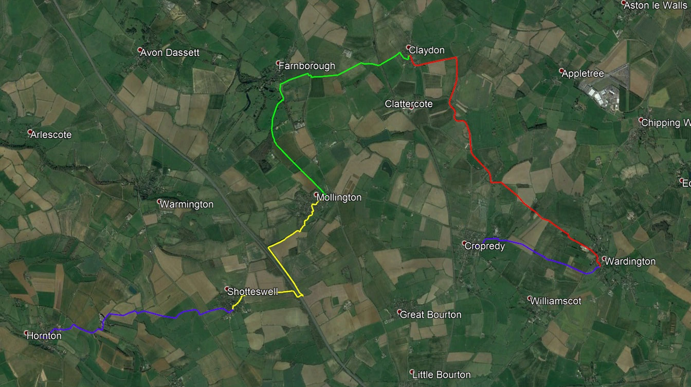
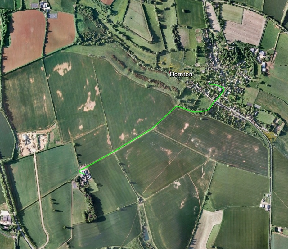
From the farmhouse, return to the track, turn right and go into and across the farmyard to a gate (bridleway markers). Go through the gate and follow the track which eventually curves downwards and rightwards and then to the left (this hollow way is likely to be muddy) to bring you into the village of Hornton (playground on left). Go straight on past the Primary School on your left and turn left down Church Lane to reach the Church of St John the Baptist. |
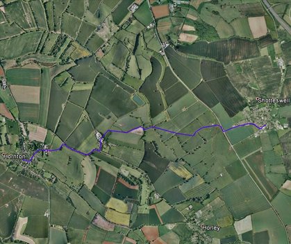
Part 26 - Hornton to Shotteswell
Turn left out of the church, leave the churchyard and continue to the main road. Cross this and the Green and turn left up the road, passing Pages Lane on the right and going on up Eastgate, keeping right, to a gate and a stile (footpath sign). Go through the gate or over the stile and follow the lane up rightwards to a further gate. Go through this and to the barn ahead of you. Turn left and then right between the barn and a silo (foot path marker), then through a gate (foot path marker) and on through further gates (foot path marker) into the field. Follow the right-hand field boundary to the corner of the field, turn left and continue along the boundary to the stile at the next corner (footpath marker and sign) and onto the road. Turn right and follow the road. At the top of an S-bend turn left into Horley Business Park (road sign HORLEY BUSINESS PARK, GLEBE FARM; footpath sign SHOTTESWELL 1 1/2 . At the first building turn left towards barns and then, before the barns, right to reach the top of a downhill track. God down this and through or round the gate (footpath marker D’ARCY DALTON WAY on the left after the gate). Continue down the track and at a gatepost (footpath marker D’ARCY DALTON WAY) turn right into the field and go diagonally across it towards a bend in the hedge. Follow the hedge round the bend, continue to the field corner and turn right. Pass a field opening to reach a footbridge and stile (footpath marker D’ARCY DALTON WAY). Cross bridge and stile (ignore the direction indicated by CIRCULAR WALK marker) and go straight across the field to a further stile and footbridge (footpath marker D’ARCY DALTON WAY). Cross these (into Warwickshire) and continue along the field edge to a footbridge (footpath marker D’ARCY DALTON WAY). Cross this into the field and then go 60 degrees left up the field (aiming a little to the right of the telegraph pole in the next field). Go over the stile (footpath marker D’ARCY DALTON WAY) and on to the telegraph pole (footpath marker D’ARCY DALTON WAY). Take a slightly more leftward direction at the telegraph pole and continue to a gate and stile in the hedge. Turn left in the next field and go over the stile at the field corner. Follow the left hand field boundary and then go on down to the right of the barn (footpath marker on the telegraph pole just before the barn). Continue up the slope on a rightwards curve past a low mound to the right to reach a stile (footpath marker D’ARCY DALTON WAY) and the road. Over the stile, turn right and cross the road, continue to FIRST TURN and turn left into Shotteswell. Passing New Road on the left, turn right down Coronation Lane. Pass the first turning left downhill and continue to the Village Hall. Immediately after the Village Hall turn left down CHAPEL LANE and cross it to reach the church via a lane that passes to the right of the house ahead of you.
Turn left out of the church, leave the churchyard and continue to the main road. Cross this and the Green and turn left up the road, passing Pages Lane on the right and going on up Eastgate, keeping right, to a gate and a stile (footpath sign). Go through the gate or over the stile and follow the lane up rightwards to a further gate. Go through this and to the barn ahead of you. Turn left and then right between the barn and a silo (foot path marker), then through a gate (foot path marker) and on through further gates (foot path marker) into the field. Follow the right-hand field boundary to the corner of the field, turn left and continue along the boundary to the stile at the next corner (footpath marker and sign) and onto the road. Turn right and follow the road. At the top of an S-bend turn left into Horley Business Park (road sign HORLEY BUSINESS PARK, GLEBE FARM; footpath sign SHOTTESWELL 1 1/2 . At the first building turn left towards barns and then, before the barns, right to reach the top of a downhill track. God down this and through or round the gate (footpath marker D’ARCY DALTON WAY on the left after the gate). Continue down the track and at a gatepost (footpath marker D’ARCY DALTON WAY) turn right into the field and go diagonally across it towards a bend in the hedge. Follow the hedge round the bend, continue to the field corner and turn right. Pass a field opening to reach a footbridge and stile (footpath marker D’ARCY DALTON WAY). Cross bridge and stile (ignore the direction indicated by CIRCULAR WALK marker) and go straight across the field to a further stile and footbridge (footpath marker D’ARCY DALTON WAY). Cross these (into Warwickshire) and continue along the field edge to a footbridge (footpath marker D’ARCY DALTON WAY). Cross this into the field and then go 60 degrees left up the field (aiming a little to the right of the telegraph pole in the next field). Go over the stile (footpath marker D’ARCY DALTON WAY) and on to the telegraph pole (footpath marker D’ARCY DALTON WAY). Take a slightly more leftward direction at the telegraph pole and continue to a gate and stile in the hedge. Turn left in the next field and go over the stile at the field corner. Follow the left hand field boundary and then go on down to the right of the barn (footpath marker on the telegraph pole just before the barn). Continue up the slope on a rightwards curve past a low mound to the right to reach a stile (footpath marker D’ARCY DALTON WAY) and the road. Over the stile, turn right and cross the road, continue to FIRST TURN and turn left into Shotteswell. Passing New Road on the left, turn right down Coronation Lane. Pass the first turning left downhill and continue to the Village Hall. Immediately after the Village Hall turn left down CHAPEL LANE and cross it to reach the church via a lane that passes to the right of the house ahead of you.
|
Part 27 - Shotteswell to Mollington
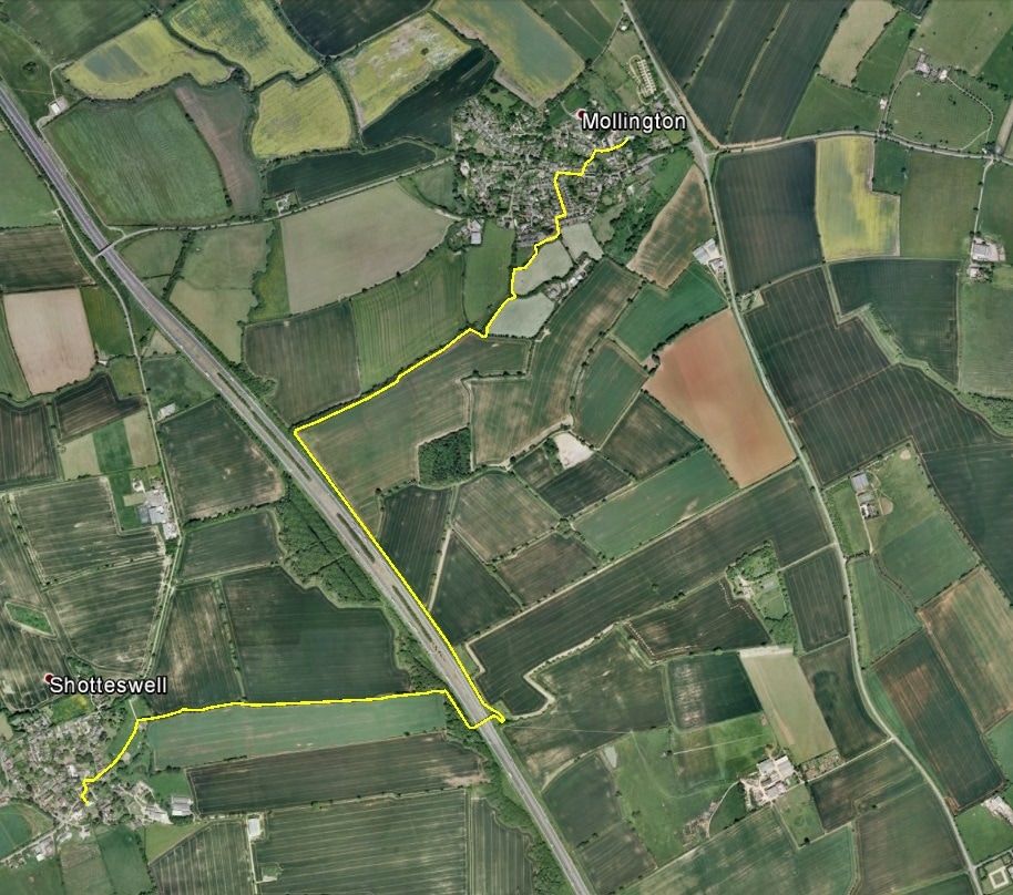
Leaving the church go to the gate straight ahead of you and down the steps to the road. Turn right, go round the left-hand bend and turn right again. Follow the road round a left-hand bend to the BAKEHOUSE LANE road sign and a footpath post indicating the D’ARCY DALTON WAY. Follow the footpath down the hill, through a gate and on to the sewage works. Pass them on your right, turning right off the concrete access road just after the gates to the works. Continue to skirt the works to reach a stile and footbridge at the field corner. Cross the stile and bridge and continue with hedge and stream to your right through two fields until you reach a footbridge and stile with footpath markers indicating D’ARCY DALTON WAY (straight on) and PERMISSIVE ROUTE (left). Taking the D’Arcy Dalton Way, cross the bridge and stile and continue along the left-hand field boundary. At the field corner, turn right and continue with the hedge and stream on your left to the next field corner. Cross a footbridge with stiles at either end. Follow the stream on your left to a further double-stiled footbridge across the stream. Cross the stream and follow the path the bridge over the motorway. On the far side ignore the gate to the left at the bottom of the bridge steps and continue about 20 metres to reach a fence post with footpath markers on it, D’ARCY DALTON WAY being indicated by a marker on the top of the post. Turn left to take the direction indicated and follow the path through a thicket of trees back towards the motorway. Turn right at the fence and continue with the motorway to your left for about ½ mile until you reach a field corner where you cannot go further along the motorway. . Turn right and walk up the field edge until just after the hedge makes a right turn to reach a stile. Cross this and follow the path between hedge and fence on to the village, crossing a stile en route. At the end of playing field, turn right in front of the houses ahead to emerge into the Village Hall car park. Go through this and follow the road up through the houses, turning right and then left and passing THE HOLT on the left to the top of CHESTNUT ROAD. Turn right at the road junction (onto MAIN STREET) and then left about 100 metres on at a footpath sign (ROUNDHILL RD, D’ARCY DALTON WAY). Go up the hill and turn right at the road (this is CHURCH LANE). Continue round a left-hand bend to reach the path to the churchyard gate and Mollington church as the road begins to descend rightwards. |
|
Part 28 - Mollington to Claydon
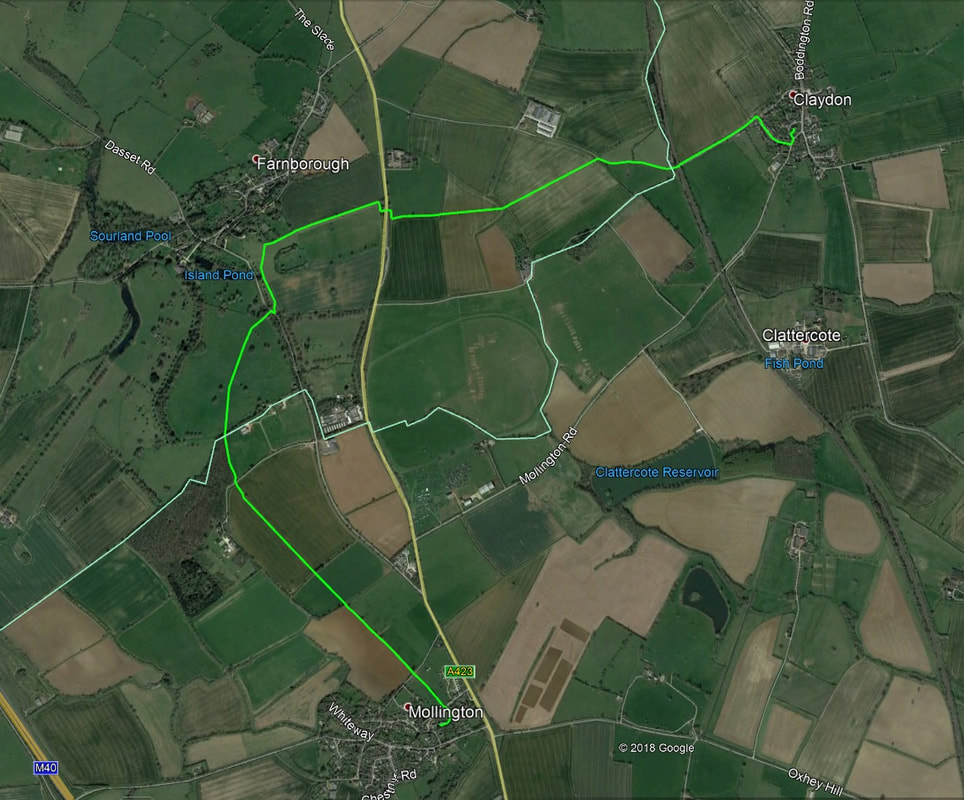
Leaving the Church, turn left along the path, go through the east gate of the churchyard and left along the grass track. Cross a driveway and then a stile (D’arcy Dalton way marker). Continue straight ahead to a gate. Go through this to a further gate and stile. Go through the gate or climb the stile and cross the road. Go through another gate (footpath sign: Farnborough 1¼ miles) and continue along the right-hand field edge to the field corner. Go straight across the next field towards the left-hand side of a group of trees in the hedge ahead. Go through the hedge (footpath post) and straight on towards a telegraph pole, then towards an isolated tree in the field and on past the tree towards a fence in front of a wood. Cross the road in front of the fence, go through the gate and continue with trees to your left to the far left-hand corner of the field. Go through the gate into the park of Farnborough Hall (National Trust sign). Turn half right and continue until Farnborough Church spire comes into view. Aim slightly to its right and curve rightwards as you go down the slope to reach a wall and then two gates leading to the road. Turn right at the road and after about ten metres cross it to reach some gates. Go through the left-hand gate at a National Trust sign and continue towards Farnborough Church. At the corner of the wire fence to your right continue on and take the path that runs diagonally rightwards up to the churchyard gate. At the gate (if you do not want to visit the church) turn right and follow the field boundary, going through a gate and continuing with the hedge to your left to the corner of the field, beyond which is a house (Park Lodge). Turn right downhill to reach a gate in the fence. Go through this (bridleway marker) and down the driveway to reach the main road. Cross the road (footpath / bridleway marker post) and continue on to a gate. Go through this, turn right and immediately left along the hedge to reach a gate at the far right-hand corner of the field. Go through this and continue straight ahead (aiming slightly to the left of a telegraph pole ahead of you (ignore those to the left). Go through the gap in the hedge before you reach the telegraph pole and go straight down the hill, passing the pole to your right. On reaching the track at the bottom, turn right along it and continue on it to the railway crossing. Cross the railway and go up the track. After the second house on your right, turn right into the lane that leads into the cul-de-sac, Manor Park. Continue through Manor Park to the main road and then turn left and shortly left again to reach the gate of the churchyard of St James the Great Church. |
|
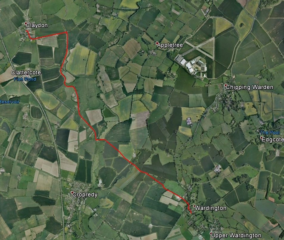
Part 29 - Claydon to Wardington
Turn left out of the church and go through the churchyard gate. On the road turn right and continue towards Cropredy (a road sign indicates CROPREDY 2 ½, CHIPPING WARDEN 3) following the road round a left hand bend and, as the road bends right at the end of the village (signed CROPREDY 2 ½), going straight on (signed APPLETREE 2, CHIPPING WARDEN 3) past sewage works on the right to reach a bridge over the canal. Immediately after the bridge turn right and right again and go onto the canal towpath. Turn left and go on for about 45 minutes to Broadmoor Lock and bridge 150. Turn off the towpath onto the road just before the bridge and turn left. Pass the buildings of Lockbund Sculpture to your right and follow the road to where it bends left. Take the bridleway (bridleway sign and marker) past the gate and go on into the field. Go straight across the field and through a gap in the hedge, then ½ right across the next field to the hedge and then left along the hedge. Cross a concrete track into trees, go across the river (the Cherwell) and, coming out of the trees, continue on the track with a ditch and hedge to your left and a wire fence to your right. About 75 metres after the end of the fence the track curves left into another field. Ignore the path rightwards across the field and continue along the hedge on your left to a point level with a hedge on the right not quite adjoining the track (the old field corner). Leave the track here (there is no footpath signage) and go about ¼ right across the field in the direction of the left hand side of a clump of fir trees on the slope in the field beyond the hedge ahead of you. On reaching the hedge, go through the gap (roughly half way along the hedge) and across a footbridge and then slightly rightwards to meet the fir tree clump at a bend in the boundary hedge. Continue up the hill with trees and hedge on your right to the top of the field, turn right and follow the fence which curves leftwards (footpath markers on a gate in the fence at the end of the trees) up to a gate at the field corner. Go through the gate and continue to a further gate at the field corner. Go through this and on past the works yard and buildings on your right. Continue out of the works area on a driveway between trees and a building, through a gate and on to the main road (do not turn right at the gate). Cross the road, turn right uphill and round a right-hand bend and then left down a road signed UPPER WARDINGTON, THORPE MANDEVILLE to reach, after about 100 metres, the churchyard gate on the right of the road. In the churchyard go straight ahead and turn right after the East end of the church to reach its south porch. |
|
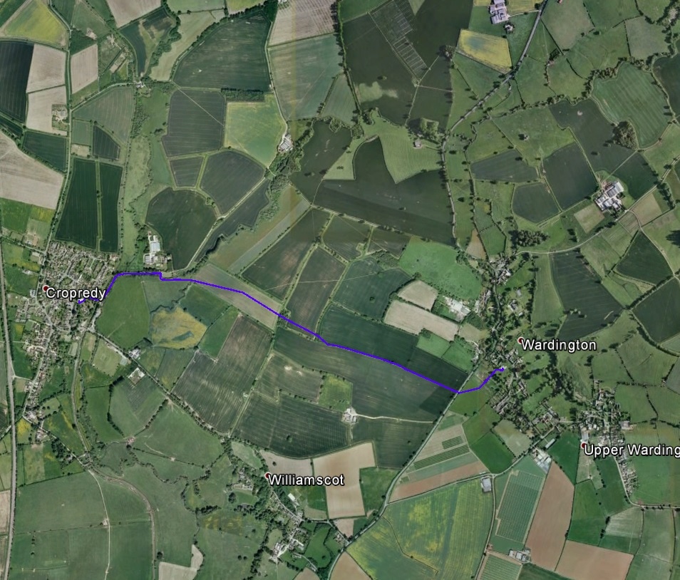
Part 30 - Wardington to Cropredy
Turn right out of the church along the path and left through the churchyard gate. Continue with allotments to your right to a further gate. Go through this and rightwards across the field passing to the right of the telegraph pole ahead of you to reach the hedge at a stile and footbridge. Go across these and across the road to a gate (footpath sign CROPREDY 1 ¼). Go through the gate and leftwards towards the first telegraph pole to reach the path. Continue to the right of the telegraph pole in the direction of the tree ahead of you to reach a hedge-end on your right (footpath marker) just before the tree. Turn right and then left to descend the hill with the hedge to your left. Go all the way to the field corner and turn right along the bottom hedge for about thirty metres to a large tree and a gap in the hedge (alternatively, about half-way down the hill cut diagonally slightly rightwards across the field to this gap – this is the official route of the footpath). Go through the gap (there is a footpath marker on the far side of the hedge). Go across the next field towards the middle of the group of tress ahead of you at the far side of the field to reach an entry into the trees (Battlefields Trail marker). Follow the path through the trees slightly rightwards to a footbridge (footpath and bridleway markers). Cross this and continue somewhat rightwards and then in the middle of the field turn leftwards at a footpath junction and continue to the far left corner of the field and a footbridge (footpath marker) and gate. Go through the gate and to the right of a telegraph pole to reach the river and hedge. Continue with the hedge to your right to a gate. Go through this, over the river and through the gate on the far side. Turn left along the roadway and continue past a sign to THE OLD DAIRY on the right into Cropredy, curving right over the canal into RED LION STREET. After crossing the canal turn left immediately to pass the eastern edge of the churchyard to your right and CANAL LOCK GARDEN on the left. About 75 metres before the road junction turn right up the lane (HELL HOLE sign at bottom of the wall) to reach Cropredy church. |
| Section | From | To | Distance | Day Total |
|---|---|---|---|---|
| 26 | Horton | Shotteswell | 2.54 | 2.54 |
| 27 | Shotteswell | Mollington | 2.57 | 2.57 |
| 28 | Mollington | Claydon | 3.23 | 6.08 |
| 29 | Claydon | Wardington | 3.83 | 9.13 |
| 30 | Wardington | Cropredy | 1.58 | 11.49 |
